In the REALMAP project in year 2000, we
have developed Map Image
Storage System (MISS), in which we presented
reasonable solutions both to the storage problem
and to the real-time requirements of the system.
The system support the following properties of
the maps:
1. Compact storage size
2. Multi-scale representation
(zooming)
3. Fast scrolling ability
(panning)
The idea is that the maps are stored in
server-side database. Spatial views are generated
for the client-side application using compressed
raster image format organized so that it supports
the zooming and panning requirements. The method
includes direct access to the compressed file, which permits real-time panning. By storing multiple scales of the map, we can also
build reasonable zooming capability in the
application. These properties together allow us
to build system that is practically as flexible
as vector format, but much more general in terms
of portability. Another advantage of the method
is that it requires only a modest memory and
computing resources in order to be operational in
real-time environment. It therefore provides low
cost solution to be used in any location-based
applications. The images in MISS are
composed into semantic binary layers, which are
compressed using a context-based statistical
modeling and arithmetic coding (paper). The method is basically
the one used in the latest international
compression standards, JBIG (Joint Bi-level Image
Group) and JBIG2 with a few
differences.
The main difference
is the implementation of the direct access, which
is missing from all comparative compression
methods. Previous results indicates that if the maps
are divided into semantic binary layers, we can
compress the images by the size that is 40% of
the storage requirements by the current de fact
internet graphics compression standards (GIF and
PNG). The storage requirements are at the same
level as that of the vector formats.

Figure 1:
“Different scale of maps”
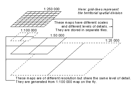
Figure 2: “Way
of representing intermediate scales”
Take a look at our
previous work(papers).
The advantages of
the MISS, however, do not solve all
practical problems in the usability of the maps.
For example, the user still must first select the
map prior to its use. Alternative solution is to
store a large collection of maps in the client
device. However, this is not feasible in many
mobile applications as there are definitely lots
of other use for the limited memory resources
than to store large map collections.
The second problem
is that the method requires maps that are already
divided into semantic binary components. In
principle, this is possible if we have vector
database as the source of the maps. However, as
we already stated before, this is not always the
case. The source maps might be stored in BMP, GIF
or PNG formats. The reading of such maps is not
any problem but we still must be able to make the
separation to binary layers.
The third
disadvantage is that the maps are generated for
predefined resolution. Although the zooming of
raster maps can be easily implemented in Windows
environment, for example, we need to implement it
efficiently in any environment and also taking
into account of the special properties of
maps.
Previous
results
|